Trip Details at a Glance:
- Skill Level: Challenging – Strenuous (there are some steep, hand over foot sections; lots of ascending and descending)
- Mileage: 20 miles
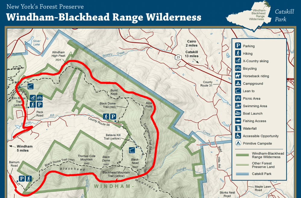
- Location: Windham-Blackhead Range Wilderness, Maplecrest, NY
- Trailhead: End of Peck Road Maplecrest, NY (link to Google Map)
- Highest Elevation: 3,980′
- Summits: Windham High Peak (3,524′) | Burnt Knob (3,180′) | Acra Point (3,100′) | Blackhead (3,940) | Black Dome (3,980′) | Thomas Cole Mtn (3,940′)
This week’s article is dedicated to a recommended two-day backpacking trip in New York’s Catskill Mountains. This is a loop that we custom created. We literally sat down old school style (nothing wrong with it) with maps of several wilderness areas in the Cats, created loops and selected that one that was most appealing. The thing that some people don’t realize is how much time and planning goes into custom routes. It can take hours! However, it is extremely satisfying when you create a trip, execute it, complete it, and then think back on how cool the trip turned out.
Having never gone to the Catskills, we were excited at the opportunity to expand our maps. We gathered a group of us (Chris and I and our friends Shawn and Kevin) and hit the road to Maplecrest, New York after work on a Saturday evening. From the Charlestown/Westerly, Rhode Island area it was about a 3.5 hour drive.
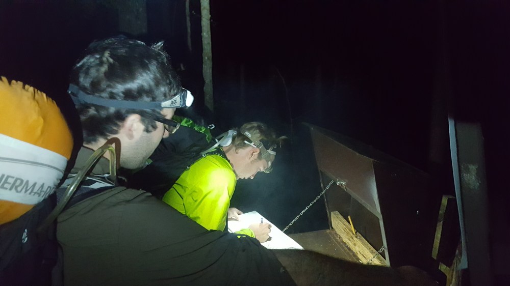
The trailhead parking lot was located at the end of Peck Road off of County Route 56. If you are arriving at night to camp before your first day of hiking, there is a lean-to and designated camping about .5 miles up the Escarpment Trail from the Peck Road parking lot. However, it is difficult to find at night even with headlamps as it is not clearly marked. You must keep looking off to the right to notice the path leading up to the lean-to and a large clearing behind that for camping, and a privy. Unfortunately, most of our group hiked straight past the camping area and had to backtrack.
With that said, to this day, this is one of my favorite camping spots. The clearing is large and flat and proved to be great for group camping. We had three tents to set up and wanted to do so in a way where we could still socialize while in our tents that next morning. This was simple for us given the large clearing and levelness of the land. Although we could not see it the night we arrived, there was a mountain view between the trees behind us. The camp was at a low elevation, which was great as far as sleeping in warmer temperatures vs. cooler temperatures closer to elevation. The camping area also offered a privy for its campers, a lean-to & large fire pit was available for shelter to shelter hikers.
The first part of the hike covers a road section: all of Peck Road taking a right back onto Route 56 until you meet up with Barnum Road and bear left. Barnum Road will lead you up a hill that only keeps going up, and up, and up until you reach the Black Dome trailhead. The Route 56 portion of the road section offers beautiful fields with mountain views in the background along with old picturesque farmland and barns. We even spotted a Bald Eagle on this part of the trip! Barnum Road offers more woods and less homes while climbing up, and up, and up. The Black Dome trailhead will be marked with an information stand on the left.
Once you reach the Black Dome trailhead, you will hike for a bit through some fast moving trail and then start climbing through a technical hand over foot rocky section. The final ascent to your first view will be a hand over foot climb (see end of video footage below courtesy of our best bud Shawn Overend).
During our trip, we encountered an angry thunder, lightning, and rainstorm that required us to take cover under one of the ledges prior to the final climb to our first view. Once we reached the first view, we witnessed the clouds giving way to the mountains and heard a music festival off in the distance. I will never forget our base layers being so wet and cold that at one point we took a break and huddled together with our warmest layers on in an effort to quickly warm up. Once the rain stopped and we got moving we quickly heated up to a more comfortable temperature again (not enough, though, to take off my down jacket – glad I had it. With it being so light and packable, I never leave for a trip without it; no matter what season or how warm the day is expected to be).
Following our first view we hiked on to our first 180 degree opening of mountains that stretched to the horizon. Then, we continued on through forests that looked like they could be from Narnia. They were some of the coolest forests I remember from this season. There was, however, a lot of ascending and descending throughout this trip, which is why we rate it as challenging/strenuous (see additional video content below courtesy of our best bud Shawn Overend).
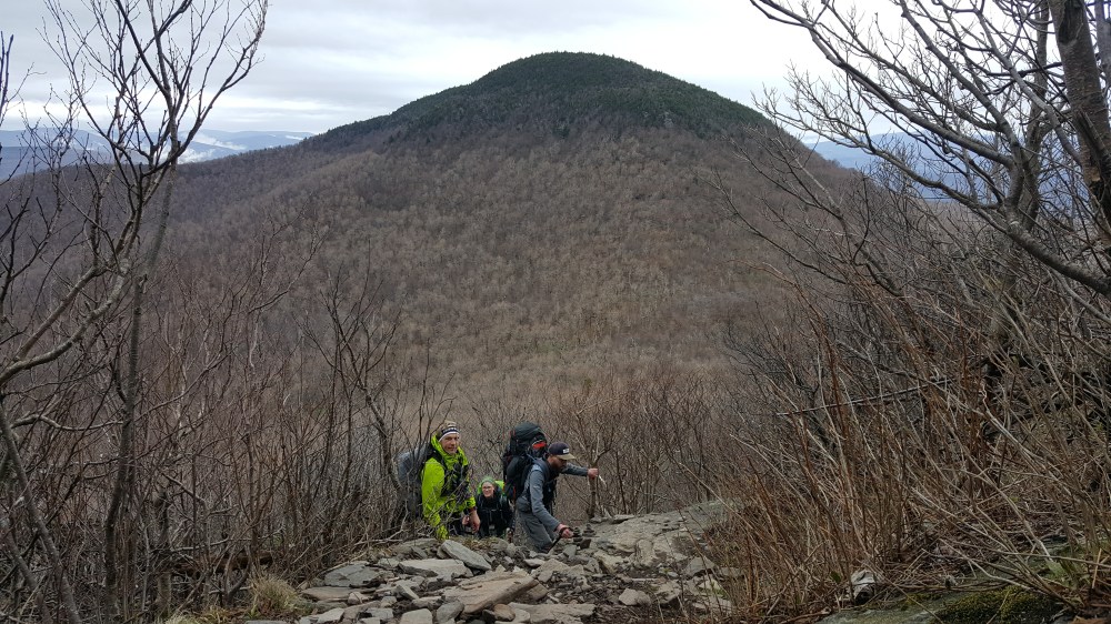
From your first 180 degree mountain view, you will continue on to descend Black Dome from Blackhead Mountain Trail (yellow markers) and ascend Blackhead Mountain. You will reach a descending section of the hike where you can see Black Dome directly in front of you – your next ascent.
Once we had ascended Blackhead there was a great view of Black Dome behind us.
We then continued onto Escarpment Trail (blue markers) to Batavia Kill Trail (yellow markers) where we made camp at the Batavia Kill Shelter. There is a lean-to and water source at this shelter. A stream flowed right nearby through the center of the tenting area. The camping area was a bit strange and some spots were extremely wet due to the rain earlier in the day. It was newly logged and cleared (we did this hike in the Spring of 2017). We had to flatten and clear an area of some debris, but there were plenty of stumps around for camp chairs (lots and lots of stumps). The lean-to was separated from the camping area by a hill and the stream. There was no privy that we could locate. This night in particular, we did not have a fire mostly because of the wind. We strategically huddled the tents as close as we could for added protection for our stoves when cooking dinner. Overnight, it got even windier. The wind was howling what felt like 50-60 mph.
The next morning we ate breakfast, had some coffee, filtered water, and packed up camp to get on our way. We headed back out onto the same section of Batavia Kill Trail that led us to the shelter, to Escarpment Trail (blue). We headed for Acra Point and Burnt Knob, which would offer us a views of the three peaks we had covered the day prior.
The second day offered us many views on the Escarpment Trail before we made our final descent back towards our first night’s camping spot and the trailhead on Peck Road. We stopped for lunch along the way before making it to one final lookout point with storybook mountain ridge trails.
On the descent down, we stumbled upon a breathtaking forest of lifted roots. Something I have only seen on this trip in particular so far. It felt surreal, but was truly rad. I remember really feeling the descent in my knees this trip as you are going down for quite a while. The final descent wasn’t as steep as some of the other sections of the loop.
Once you reach the trailhead again, there is a small stream that runs parallel to the parking lot if you’re looking to wash up or cool down a little before your car ride home. Also, even better, at the end of Peck Road there is a river with a small waterfall and small swimming pool if you want to really cool off and feel like a million bucks (this was wonderful after a hot and sweaty day of hiking at the beginning of May).
All in all, this was a great trip. We fell in love with the Cats and cannot wait to plan our next trip that way. This trip was a great way to work up towards our first 4,000 footer of this season (happened on the trip following this one – a loop also in the Catskills).
Trail Directions for 20 mile loop with two nights of camping & two days of hiking:
- Peck Road Trailhead to Escarpment Trail (Blue Markers)
- .5 miles down Escarpment Trail to Lean-to/Designated Camping Area
- From designated camping area, head .5 miles back to Peck Road Trailhead
- Continue down Peck Road to Route 56
- Bear right on Route 56 and follow all the way to Barnum Road
- Take a left onto Barnum Road and follow to Black Dome Trailhead (Red Markers)
- Follow Blackdome Trailhead (Red) until it meets up with Blackhead Mountain Trail (Yellow)
- Continue onto Blackhead Mountain Trail (Yellow) until you meet up with Escarpment Trail (Blue)
- Follow the Escarpment Trail until it meets up with Batavia Kill Trail (Yellow)
- Take Batavia Kill Trail to the designated camping area and lean-to to camp for night two
- Backtrack on Batavia Kill Trail (Yellow) to Escarpment Trail (Blue) bearing left
- Follow Escarpment Trail (Blue) for the rest of the trip until you reach the Peck Road trailhead
As always, your readership and support is greatly appreciated. Please feel free to leave us comment or send us an email with any thoughts or suggestions (fullscend@gmail.com).

Any clue the elevation gain?
LikeLike
Great question – not exactly. I can look back on my Garmin and try to figure it out for you, but I will say that I recall a lot of ups & downs. Also, N.Y. offers an interactive mapping tool on their wilderness sites that might be able to help here.
LikeLike